

Copied from www.volcanocafe.org, July 2017 by Albert
reprint by PA0ABM
I found this article on ww.volcanocafe.org after lot of investigations on Bouvet Island. It tells even more
about this barren Island at the end of the world.
If you want to get away from it all, this is the place for you. If you prefer to experience your volcanoes in
utter isolation, you could not do any better. If you have seen it all, come and see this. Find yourself a
globe (for younger readers, this is a historical version of google earth without a zoom), and locate
Bouvet Island. You will find it where the Atlantic Ocean and the Southern Ocean meet (a magnifying
glass may be required). Draw a circle around it (permission from the owner of the globe should be
sought). Within a radius of 1000 kilometer, you will not find not another speck of land. There isn’t even a
shipping lane. The nearest significant land area is Antarctica, 1700 kilometer away. The closest human
settlement is Trista da Cunha, which is over 2000 kilometer distant, and is itself not particularly well
connected. Cape Town and South Georgia are both 2500 kilometer away. In comparison, the
International Space Station seems suburban. Go to Bouvet Island, and you will be the loneliest person
on Earth. Only the 24 astronauts who have gone to the moon will have been further away from the rest
of the world than you.
Getting there might be a bit of a journey, and visits tend to be few and brief. It is not only isolated, the
surrounding ocean is as inhospitable as it comes. Think roaring forties – but in the fifties, and much
colder. The average temperature in summer (January) is +1C, and the dominant weather is cloudy to
foggy with storm. Precipitation is about 1 meter per year, largely as snow.
Bouvet is difficult to land on even in good weather, on account of the strong surf, which can quickly
swamp a boat. It can be even harder to get off the island! There may be 2 to 4 storms each week, with
little calm weather in between, and from March to October the island may be entirely inaccessible due to
the relentless weather.
Through an accident of history, related to whaling, Bouvet Island is now a Norwegian possession. You
wouldn’t have guessed, although the climate does provide a hint. It is a UNESCO world heritage site, an
honour it shares with Mount Etna, the Hawaiian and the Kamchatka’s volcanoes. But you will be hard-
pressed to find the visitor centre. Norway likes to put its protected environments where no one will be
inconvenienced. (15% of its national parks are on Svalbard!)
Bouvet Island (called Bouvetøya in norwegian) is 49 square kilometer in area. About a quarter of this is
taken up by a caldera, called Wilhelmplataet. The highest point of the island is on the caldera rim,
Olavtoppen, at 780 meter; it was climbed for the first time only in 2012. The ice-filled caldera itself is 250
meter below the rim.
Expedition to the summit
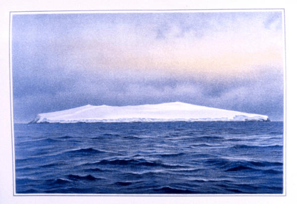
The ice cover of the island is impressive: the black volcanic rock peaks out only at the coast. The rocky
beaches especially on the west side are ice-free, but in most places the glaciers get rather close to the
edge of the island. In the east, the ice cliffs tower 50 meters above the beach. About a third of the coast
line has glaciers flowing into the sea; elsewhere, the rock cliffs are too steep to support a glacier, and
the glacier ends above the cliff. The glaciers appear to be quite thin. How deep the ice is inside the
caldera is not known: the summit is in almost perpetual cloud and very few people have been on the
caldera.
A low-lying shelf exists on the west coast, called
Nyrøysa, which appeared sometime between 1955
and 1958. It is 2 kilometer wide, 500 meter deep and
up to 50 meters high. For a while it was thought it had
formed from a volcanic eruption, but later it was shown
it must have come from a land slide. Elsewhere,
much of the coast line is a steep cliff. The new shelf
made landings much easier, and it was used to build
shelters and automated weather stations. But they
tended not to last, and often had disappeared by the
time of the next landings. The cause is the catabatic
winds coming down from the ice dome which can
reach speeds up to 200 km/h.
There is one tiny satellite island to the southwest,
Larsøya, which is ice-free.
If you like vegetation, there are some mosses and liverworts, and you can find a few lichens. Some of
this has grown on the shelf, but most is on an ice-free region on the south coast, a few hundred meters
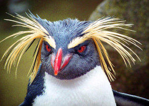
up. Animal life is more abundant, in the form of seabirds, penguins, seals and elephant seals, principally
on the western coastline. Many of the seals congregate on the Nyrøysa shelf on the west coast. There is
also a large penguin colony there, of three different species, and one of the studies comments on the
large loss of nests due to ‘interaction with seals’. I guess the egg shells have difficulty carrying the
weight of several tons of elephant seal.
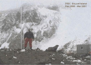
Bouvet Island has legendary status among ham radio
enthusiasts. One of the ultimate achievements is to
record worldwide contacts from this extreme location.
The first to achieve this aim was Gus Browning in
1962, and the best-known ham operator here was
Chuck Brady, who worked at a research station from
December to early March in 2000/2001. Chuck
(N4BQW) used a Mike Traffie HX-5B HEX-BEAM to
make near 17,000 contacts. His team left the island
only just in time: the recovery mission almost failed
due to the autumn storms, and they left with only half
an hour to spare. Chuck had previously flown as a
NASA astronaut on the space shuttle. I wonder how
the two experiences compared!
Volcanic activity
All deep-ocean islands are volcanic in nature. And because islands erode pretty fast, they tend to be
younger volcanoes which are still active or slightly dormant. Bouvet is a shield volcano in the final stage
of its life above water. The caldera shows that there have been significant eruptions in the past!
Evidence that there is still life in the mountain comes from the presence of fumaroles, mainly on the
north and west side, around the beaches. Reports suggest that they are short-lived. One fumarole was
on a beach that eroded away, and has gone, and others show decline while new ones appear. It is
possible that the fumaroles are activated by landslides: over decades the newly-exposed rock cools and
the fumaroles disappear. In the Landsat image at the top of this post, there is a central peak in the
caldera which shows there was an eruption after the caldera had formed. But it is not possible to see
any details as it too is completely covered in snow.
The cliffs on the coast of Bouvet Island contain two main layers. The top layer contains a series of lava
flows, with a few volcanoclastic deposits thrown in. The flows are largely basaltic, and have come from
the caldera area. Only the youngest ones (Kapp Valdivia, Larsoya ) are rhyolitic and have formed domes
on the flanks of the volcano. (A lava flow at Cape Meteor on the eastern flank has been argued to be
2000 or 4000 years old, but I have not found the source of this date.) The lower layer is made up from
breccia and tuff, which formed in older, pyroclastic events. They may even have formed under water, as
hyaloclastite.
The lower layer is quite soft and because it is at sea level, it makes the island rather susceptible to wave
action. The wave erosion undercuts the cliffs; the result is landslides, which form beaches of debris. The
beaches are quickly removed by the waves and the process begins again. In this way Larsoya became
a separate island: erosion removed its link to the main island. The Nyrøysa shelf is eroding at a rate of
between and 1 and 4 meters per year. How bad the erosion has become can be seen from the location
of the caldera. It should be at the centre of the island, but instead it is on the western edge. The offset
caldera makes the island look lopsided. It is caused by many centuries of wave erosion. The incessant
westerlies have eaten away the exposed side of the island, and the erosion has now reached the
caldera rim. That already tells you that Bouvet is in decline. The eruptions can’t keep up with the erosion
and the island is getting smaller. Bouvet is past its prime and heading for retirement.
The landslides bring the basaltic rocks down to sea level, and the wave erosion turns it into a rough
sand of basalt. In any other place, these blackest of black beaches would be famous. But here, in utter
isolation, only the seals leave their impressions.
Exploration
How did a Norwegian volcano (rare enough to begin with) end up with a
French name? It came from Captain Jean-Baptiste Bouvet de Lozier,
who discovered the speck in 1739. He saw it from a distance and did not
sail around it: he reported it as the discovery of the southern continent.
Due to its isolation and a map of rather questionable accuracy, it was not
found again until 1808. James Lindsay re-discovered it, hundreds of
kilometers from the position given by Bouvet, and named it Lindsay
Island. One captain George Norris re-re-discovered it in 1825 and it
acquired yet another name, Liverpool Island. He also reported a second
island, 70 kilometer away, which he called Thompson island; it was
never seen again and most likely never existed.
Because of this confusion, UK claims were deemed invalid, as it wasn’t
clear which of these four islands they claimed, and the Norwegians ran
away with the ownership.
Bouvet Island now has a registered internet domain, .bv. However, this
domain has no known web sites.
Geology
The Mid-Atlantic Ridge (MAR), where the oceanic crust of the Atlantic Ocean is formed, runs from
Iceland southward, ending at the Southern Ocean. Here it meets a complex fault which runs
approximately east-west, connecting the southwestern part of the Indian Ocean Ridge to the South
Sandwich Islands where a subduction zone is pulling in Patagonia. The end-point of the MAR is called
the Bouvet Triple Junction – not entirely correct as Bouvet island is 250 kilometer away but there was
nothing else here which could provide a name! The fault is called the Conrad Transform towards the
west, and the Bouvet transform to the east, and separates the stable Antarctic plate, the African plate
and the South American plate. Bouvet Island lies just south of the Bouvet Transform fault.
(Norway is in the curious position of owning both the southernmost (Bouvet) and northernmost (Jan
Mayen) island of the MAR – and nothing else. And both
are named after non-Norwegians.)
Between Bouvet Island and the MAR is the mysterious
Spiess ridge. This is a massive volcanic feature, 80
kilometer long, with reaches to 320 meter below sea
and has a large caldera. It seems young, perhaps 1
million year, although this is not well known.
Just looking at the sketch below shows how broken up
the area is. Originally this was a more conventional-
looking triple point, located some distance south of
where the MAR ends now. The triple point moved up
north, and every time it moved north the Conrad and
Bouvet faults re-formed further north. The Spiess ridge
appears to be one of the MAR sections that broke off,
but another suggestion is that it was the formation of
this ridge which caused the triple point to migrate
northward.
‘Triple point’ is a funny expression, as in fact it is one point, not three. It is a place where three faults
meet, so perhaps should be called ‘triple fault’, but as this would be confusing, sometimes it is called a
‘triple junction’. Each of the three faults can be of three varieties: a ridge (R), a trench (T), or a transform
fault (F). A ridge forms if there is extension, i.e. seafloor spreading: you get a deep valley (a graben) and
associated volcanism. A trench forms if there is subduction. A transform means that both sides slip past
each other. Within a continental plate such a fault is called a strike-slip, but if it is between two different
plates it is called a transform fault. Pure transform motion, sideways, is actually quite rare. An example
of one is the South Iceland Seismic Zone. More commonly, a fault shows a bit of both extension and
slip, as is the case on the Reykjanes Ridge. This case happens, for instance, where a strike-slip fault
has a bend: you get areas of extension and areas of slip. This is called ‘transtensional’.
A triple junction is classified by which type of faults meet, for instance R-T-F if there is one spreading
ridge, one subduction trench, and one transform fault (a somewhat unlikely configuration). An example
of an R-R-R triple junction is at Afar, connecting the Red Sea, the Gulf of Aden and the African Rift. The
end of the San Andreas fault, the Mendocino Triple Junction, is F-F-T. An F-F-F junction is physically not
possible.
The Bouvet triple junction started out as an R-F-F junction, 20 million years ago. Currently the Conrad
and Bouvet transforms are at an angle with respect to each other, but that is because the South
American plate has rotated since. Originally, the two faults were parallel and would just have been the
extension of each other. Later, the triple junction started to move north, the Conrad/Bouvet fault broke
into pieces, and became R-R-R as spreading ridges.
At Bouvet Island, the spreading rate is currently 1.5 cm/yr. A deep valley has formed, but the southern
wall of this valley is a kilometer higher than is should be, for unclear reason. This is where Bouvet Island
is found.
Why did the ridge here, and only here, become volcanic? Noone knows. There is speculation about a
‘Bouvet Island hot spot’ but there is not much evidence for it. A thermal anomaly has been proposed, but
this is just another word for a hot spot (albeit without the connotation of a plume). The lack of land over
such a large surrounding area already shows that the region is not particularly volcanic. There are no
island chains or even submarine chains.
Age
When did Bouvet Island form? Based on the distance from the newly formed spreading ridge, and the
known spreading rate, the crust is dated to 4.5-5 million years. The volcano cannot be any older than
that! The bedrock of the volcano is dated to 1.4 million years, and well-dated rocks around the 1950’s
landslide are around 0.5 million years, so by that time the volcano existed. All measured rocks have
normal magnetic orientation, meaning that they are younger than 1 million years: before that time, the
magnetic field was reversed for a long period, but this is not seen in the Bouvet rocks. They all formed
after the last field reversal.
The rate on erosion can give a rough age of the island. The 1950’s landslide formed a shelf 2 kilometer
wide, 500 meter deep and on average 10 meter tall. This gives a total volume of 0.01 km3. The west
side of the island has been eroded back by perhaps 5 kilometer. Assuming an average height of 400
meter, and a width of 5 kilometer, the eroded volume is 10 km3. If we assume that such a collapse
happens once a century, the erosion has taken 100,000 years. At this rate, the island would erode by 5
cm per year which seems a bit high so perhaps such large collapses are not quite as frequent. At 1 cm
per year, the age becomes half a million years. This is probably within the right ballpark. This poor island
has never seen warm weather: when it popped up from beneath the sea, the ice ages were already in
progress.
In another half a million years, Bouvet Island will have gone. Enjoy it while you can.
The mystery of the deserted life boat
Bouvet Island is home to its very own Marie Celeste mystery. In 1964, a team helicoptered in from HMS
Protector found an abandoned lifeboat, half submerged in a lagoon on the newly-formed shelf. The
leader, Alan Crawford, wrote What drama, we wondered, was attached to this strange discovery. There
were no markings to identify its origin or nationality. On the rocks a hundred yards away was a forty-four
gallon drum and a pair of oars, with pieces of wood and a copper flotation or buoyancy tank opened out
flat for some purpose. Thinking castaways might have landed, we made a brief search but found no
human remains. Clearly people had come ashore with very limited supplies, but there was no indication
from where they had come, why, and how (if?) they had left.
The boat must have arrived after 1955 as the shelf did not exist before that. It could not have made a
sea journey of any length. Whoever used the boat to get to Bouvet Island, left no other trace, but did
have enough man power to drag a heavy boat 30 meters over rough stones away from the sea. Did a
ship flounder and the poor survivors ended up here? Where they eaten by the elephant seals?
(Unlikely.) Rescued in secret?
The mystery was described brilliantly by Mike Dash in a blog article of 2011. He did a trail through all
reported ship losses showed nothing. The answer was slowly pieced together by the various
commenters on the blog, in a piece of exemplary citizen detective work, and the following is based on
their work. There are two parts to the answer. The second part was by radio, and the first involved birds.
Let’s begin with the second part of the answer. In 1962, the ham enthusiast Gus Browning came to
Bouvet Island to pioneer radio transmissions from
there. A far-flung (expensive) ham radio trip is
called a DXpedition. Browning (W4BPD) visited
Bouvet on his second DXpedition, from 26 to 28
November 1962. According to his own description,
he landed at Cape Circoncision, at a flat area about
the size of two football pitches. This must have
been Nyrøysa, the only flat bit in the area, and not
badly placed for his purpose. Radio signals to Asia
are blocked from there by the island, but America
and Europe would have been reachable. Browning
brought a large petrol drum – forty-four gallon is
about the right size. The copper box, opened out
and flattened, would have been very useful to
ground his antenna, although it seems a bit strange
to bring damaged ware with you on such an expedition. Browning had hitched a lift on an icebreaker,
and was taken to the island by life boat. The boat returned three days later to pick him up. However, that
boat certainly had not floundered there: he made it back safely and never mentioned such a disaster. So
it certainly wasn’t his boat that was found.
The first part to the story, involving the boat, began in November 1958, when a Soviet vessel visited
Bouvet Island on an ornithological expedition. A report was published in the Information Bulletin of the
Soviet Antarctic Expedition, volume 13 (1959), pages 97-99, by Gennady Solyanik, with the exciting title
“Some Bird Observations on Bouvet Island”. The vessel, the Slava-9, was part of the Soviet whaling
fleet, but their scientific work was done in the context of the International Geophysical Year. Slava-9
would have had two rowing boats, each able to carry 24 men.
A party of 10 men, scientists and sailors, including Solyanik came ashore close to Cape Circoncision.
Again, this almost certainly was on the newly formed Nyrøysa, which had just formed and was by far the
best landing place. Shortly after their arrival a hurricane began making it impossible for them to return.
The boat would not have been up to that weather. They stayed there for three days, time used for more
bird observations than they had planned! When the storm finally subsided, the man were evacuated with
the Mi-1MG helicopter carried on the Slava-9. The helicopter pilot was Averyan Rzhevskiy, who later
wrote about this event. The boat was left behind and found its final resting place here. The lagoon may
not have been there yet: the rock fall would have compacted over time, and storm filled in the
depression -and the boat- with water.
Gus Browning must have come ashore at the same place as the Soviet researchers, and found the
camp left by the previous expedition. After four years, the boat would already have been in poor
condition. The copper box was used as a flotation device on the boat. Browning found it, and put it to
good use, and added his own debris to the camp site. But he didn’t report any of this – to him only the
radio counted. In this way he left a double mystery, and became a beachcomber, the scavenger of the
Marie Celeste of Bouvet Island.
Aliens
In 2004, the movie Alien vs. Predator hit the cinemas. It is set on the not-so-mythical island of
Bouvetøya. Wikipedia writes: This film follows a group of archaeologists assembled by billionaire
Charles Bishop Weyland (Henriksen) for an expedition near the Antarctic to investigate a mysterious
heat signal. Sadly, the budding volcanologists go for the wrong heat signal, instead of interesting
eruptions they uncover a pyramid, and mayhem begins.
This film is well worth missing, and although set on Bouvet island, it wasn’t actually filmed there, so it is
of no volcanological interest either.
The end of the world
Bouvet Island would be a good place to site the
Restaurant at the End of the World. It meets all
requirements, including a total lack of other
customers. The main menu will be penguin omelet
with an algae side dish, and the fumaroles provide
just enough heat for the hot plate. Better stay
indoors – because of the ice and the clouds, there is
not much to see, making it ideal for people who have
seen it all. And from experience I can confirm that a
penguin colony smells atrocious.
But underneath the ice lies a hidden world of which
we know little. The caldera and the pyroclastics provides evidence for a violent past, but we don’t know
when. And how did this volcano form? If it is related to the migrating triple junction, why is it not at the
triple junction? Why is there no other volcanic island within 1000 kilometer? And why is it dying? The
abandoned boat may have been the easiest of Bouvet’s mysteries. There is more here than meets the
eye. Aliens, anyone?
Albert – July 2017
Sources
Earth observatory
Travel log from Bouvet (Norsk Polar Institutt)
Some bird observations on Bouvet Island
Chuck Brady on Bouvet Island
The expedition to the summit
The Norwegian Antaretie Research Expeditions 1976/77 and 1978/79
An abanded lifeboat on Bouvet ( See comment dated 26 FEBRUARY 2016 AT 11:21 PM, Mike Dash)
The island at the end of the world, Bouvetøya






DXing - Stories 04















